Shuttle’s Eye in the Sky Is a Way to Fight Smog : Endeavour’s downlink to Earth provides a real education in environmental science.
- Share via
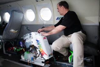
While the space shuttle Endeavour was flying over Ventura County earlier this week, I listened via a special phone hookup by way of the Kennedy and Johnson space centers to the astronauts talking about what they saw. Billed as an “environmental shuttle,” their vehicle carried the most advanced radar ever flown in space for environmental monitoring--capable of delivering three-dimensional images, day or night, penetrating clouds, vegetation and even the surface of a desert. Also on board was a device to measure carbon monoxide accumulation--one of the constituents of smog--anywhere on earth.
I heard veteran astronaut Peter (Jeff) Wisoff explaining to a reporter at Cape Kennedy that all this equipment added up to “a global eye to look over our environment and keep our world a nice place to live.”
Most media reports of the 11-day flight covered what the astronauts were looking down on in Asia and the North Sea. But I was able to eavesdrop as Wisoff, a Stanford-trained Ph.D, passed right over our coast and confessed to homesickness, intoning the landmarks passing beneath him, “Monterey Bay, the Big Valley, Ventura, San Diego . . . this is my favorite run.”
I wasn’t the only person in our neighborhood keeping track of the Endeavour mission. Thousand Oaks High School science teacher Susan Thee told me “we load data (from the shuttle) right into our school computers via modem and an 800 number.” The data initially comes to Earth as computer bytes--enough to fill a carton of floppies six miles long--and is turned into pictures at Caltech’s Jet Propulsion Lab in Pasadena for scientists and students on the Internet.
“Our kids are doing real live applicable science,” Thee said. One class project involves comparing, at local sites and around the nation, the health of live oak trees near and far from freeways.
The availability of raw scientific data via modem has made possible a new approach to teaching science. Recent shuttle flights, she said, “are providing perfect stuff, actual data. I don’t want textbooks anymore. We can open up the whole world to students, not just 500 pages.”
Real-life environmental research has had some real-life effects on the students at Thousand Oaks High. According to Principal Keith Wilson, their college entrance test scores have improved dramatically since the computer-based work started two years ago.
Just a bit up the coast, at UC Santa Barbara, this week’s environmental shuttle data was greeted as “a bonanza from space,” according to UCSB’s press release.
I was able to experience the event and its impact on scientists at UCSB by listening simultaneously on two phones. On one, astronauts described the Amazon forest below them, and, on the other, UCSB biologist John Melack, who is a leading expert on the Amazon River’s flooding patterns, discussed his research based on the radar images being transmitted to Earth.
Among the shuttle’s many instruments, the one beaming down data on smog-related carbon monoxide is of local interest, since Ventura County, alas, gets poor marks from the Environmental Protection Agency in this category. The device on the shuttle is scarcely the size of a suitcase, but it has a big name and a big environmental purpose: Measurement of Air Pollution from Satellites, or MAPS.
The goal is to pinpoint concentrated carbon monoxide levels--where they’re originating and where they’re drifting.
These new shuttle pictures may eventually be combined with other data being generated at Caltech and the Massachusetts Institute of Technology. These schools and others are involved in a quest to determine “soot signatures”--the exact source of visible airborne particulates--eventually perhaps by address .
Polluters beware: Big Brother is watching from the shuttle. And kid brother too, if he’s enrolled at Thousand Oaks High School.
Details
* FYI: Science teachers interested in classroom use, via computer modem, of environmental radar data being beamed from shuttle flights and satellites can call (818) 354-2386. Information on the MAPS project: (804) 864-6124.


